


In closing the second full year of data collection within the State Geological Survey Contributions to the National Geothermal Data System project, we present a variety of success stories from the field. Some involve simple data collection, others involve new data exploration associated with the supplemental award provided by the Department of Energy’s Geothermal Technologies Program. We hope that you’ll enjoy these tales of geothermal and data preservation from across the nation.
As a reminder, funding for this project was awarded to the Arizona Geological Survey on behalf of the Association of American State Geologists by the Department of Energy’s Geothermal Technologies Program as part of the American Recovery & Reinvestment Act.
Hawaii, adapted from a submission by Nicole Lautz
 presents the University of Hawaii’s work at the 2012 American Geophysical Union Fall Meeting.")
The University of Hawaii, which is conducting the data collection efforts for the state of Hawaii, has digitized approximately 1,000 geothermal documents and made them available on the University's repository (and
provided metadata to the NGDS of course!). To date, nearly 10,000 downloads have occurred by approximately 6,000 viewers. In addition, approximately 3,500 water wells have been digitized and include groundwater and geochemistry data. Benefits of this work include the State's Commission on Water Resources Management transitioning to an entirely E-Document system for oversight and permitting and perhaps most significantly, a state-wide assessment of geothermal resources through a sequence of magnetotelluric surveys (independently funded from this project).
Having access to the digitized data will tremendously enhance the ability to interpret and analyze the MT datasets. In Hawaii, the NGDS project has stimulated cooperation between key players in geothermal development, provided enhanced accessibility to a broad suite of data relevant to geothermal resources, and galvanized new projects on geothermal exploration. This is critical to Hawaii's energy portfolio since Hawaii currently has the nation's highest electricity costs due to its use of oil (which has very high transportation costs to HI) as the primary fuel source.
Idaho, adapted from a submission by John Welhan
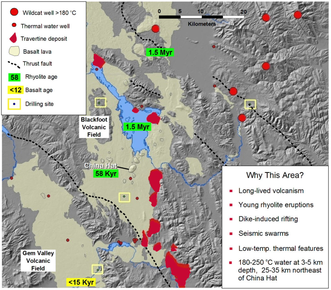
New thermal gradient wells have been drilled in southeast Idaho and are expected to provide the most accurate assessment yet of high-temperature geothermal energy potential in the region. During the fourth quarter of 2012, the Idaho Geological Survey (IGS) successfully completed installation of three thermal gradient wells in the Blackfoot-Gem Valley volcanic field (BGVF) of southeastern Idaho. The wells were drilled within a 30 kilometer (18 mile) radius of China Hat, a 60 thousand year-old rhyolite complex near Soda Springs, Idaho and are designed to measure conductive heat flow in the sedimentary rocks underlying the volcanic field. The wells range in depth from 87 to 137 meters (290-450 feet). A fourth hole was abandoned because of lost circulation problems encountered in the very porous basalts of the BGVF.
University of Idaho faculty and IGS research geologist Dr. John Welhan, who leads the project, says, “These young basalts have long impeded the assessment of heat flow in this area because they host so much ground water flow. These new thermal gradient wells will provide the first accurate picture of the heat flow regime beneath this important volcanic province." A key part of the drilling project’s success has been the on-going geothermal data compilation effort. The availability of such data has allowed researchers to formulate hypotheses on the BGVF’s geothermal potential that will be tested with the data acquired from the newly drilled wells.
The next step in the heat flow drilling program - thermal profiling of the new wells, measuring the rocks’ thermal properties, and performing heat flow calculations - will be accomplished during the first half of 2013 in collaboration with the Utah Geological Survey, University of Utah and the Idaho National Laboratory. The data will be used to develop a comprehensive analysis of the high-temperature geothermal potential of the BGVF that will become part of Idaho’s contribution to the NGDS and will be served through IGS’s server as a participating data node in the NGDS network.
Read the University of Idaho and Idaho Geological Survey Press Release on the New Data Collection.
Utah, adapted from a submission by Rick Allis

The Utah Geological Survey released the initial results of their work to discover a new type of geothermal energy resource in the Black Rock
Basin of Utah. The work tested a new concept that high temperature geothermal resources might exist beneath young sedimentary basis. Preliminary results show that near-surface temperature gradients in the basin vary from about 60 degrees C/km (33 degrees F/1000 feet) to 100 degrees C/km (55 degrees F/1000 feet). This implies temperatures of 150 to 250 degrees C (300 to 500 degrees F) at 3 to 4 km depth (10,000 to 13,000 feet) beneath the basin. An abandoned oil exploration well drilled near Pavant Butte in the central part of the basin in 1981 confirms these exceptionally high temperatures.
Seven of the nine holes were funded by the U.S. Department of Energy as part of the AASG Supplemental Funding Project. The Salt Lake City Tribune featured the story on September 27, 2012 and the research was released on Monday, October 1, 2012 at the Geothermal Resources Council Annual Meeting. The Utah Geological Survey produced a video showing the work; it is available for viewing on the UGS Blog.
This discovery was named by Seeking Alpha, a financial and stock tracking website, as one of the top geothermal events of 2012. Written by Herman Trabish and released on December 18, 2012, "Geothermal's Big 12 Events of 2012" lists the discovery at number 7. "Seven: Utah Geological Survey testing discovered a new type of high-temperature energy reservoir in the Utah-Arizona-Nevada Black Rock desert basin that showed a potential equivalent to California’s Geysers, the Calpine Corp. (CPN) fields that produce a third of the world’s geothermal energy."
Vermont, adapted from a submission by Larry Becker
Unfortunately, 2011’s Tropical Storm Irene flooded most of the Vermont Geological Survey’s (VGS) basement archives. Fortunately, most of the archives were out of the basement and being scanned as part of this project. The Vermont submission to the NGDS collection includes:
1) the entire library which included published, draft and open file maps, bound books, field trip guidebooks, volumes with multiple articles, State Geologist Reports and publications of the Vermont Geological Survey, journal articles and
2) the basement files which included mineral resource documents and maps (i.e., Brandon lignite, mineral springs, peat, phosphate etc), town and county reports (random documents pertaining to specific town issues), and sand and gravel reports.
All the above materials were out of the office at the scanning contractor when the VGS office was inundated by Tropical Storm Irene. The basement was completely flooded and the bookcases previously containing the archives were substantially affected by flood waters. As a result of this happy circumstance, the digitization and OCR project is complete and the data are available in computer formats with the paper versions returned and on library shelves.


